
When faced with time off from work and being cooped up at home, many people’s first instinct has been to get out and enjoy nature. Although it has led to some trails becoming overcrowded, states like Maine have undertaken measures and guidelines to maintain social distancing and prevent overcrowding while enabling people to access the soothing embrace of their parks and mountains.
Before you show up at any of these places, please check their official websites and Facebook pages to confirm if they’re open, accepting visitors, requiring reservations, or have any specific guidances or rules that you need to follow. We’ve included some less-popular alternatives with most of the hikes.
If you’re visiting Maine from out-of-state, please comply with Maine’s current COVID-19 policies for self-quarantining.
This article goes over what the most popular hikes in Maine are, according to monthly Google data collected from a tool called ahrefs. We then interviewed a few Maine hiking experts to get their anecdotes and tips on every location. They are:
Philip Pepin, Registered Maine Guide and owner of 100 Mile Wilderness Adventures and Outfitters
Carey Kish, Registered Maine Guide and author of Maine Mountain Guide: AMC’s Comprehensive Guide to the Hiking Trails of Maine, Featuring Baxter State Park and Acadia National Park (affiliate link)
Lester Kenway, President of Maine Appalachian Trail Club
Bonnie Farrand, Maine Outdoor Adventure Club
We’ve done similar articles about Massachusetts and Vermont.
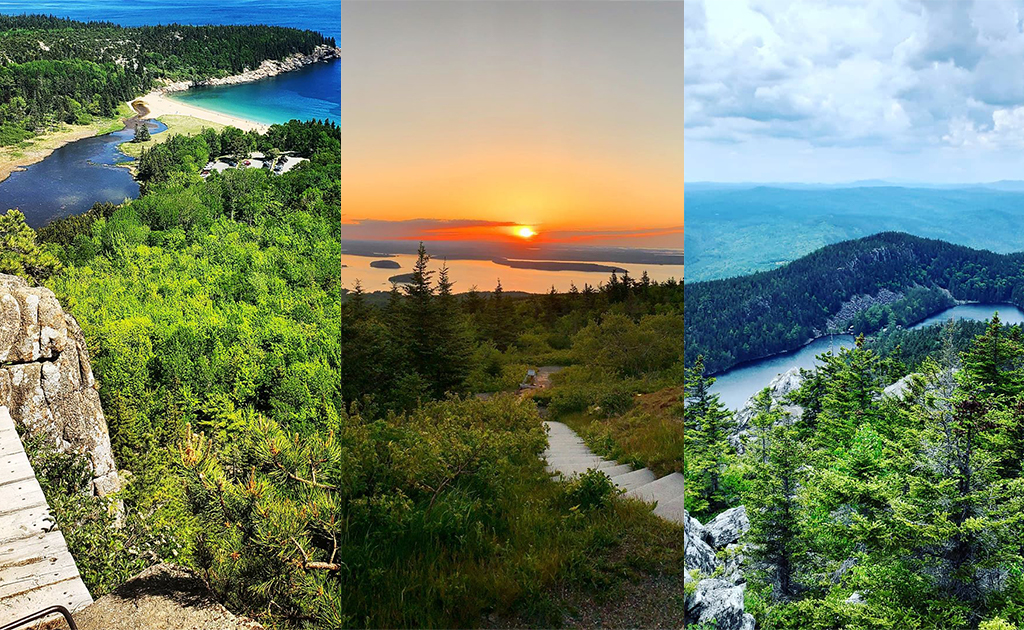
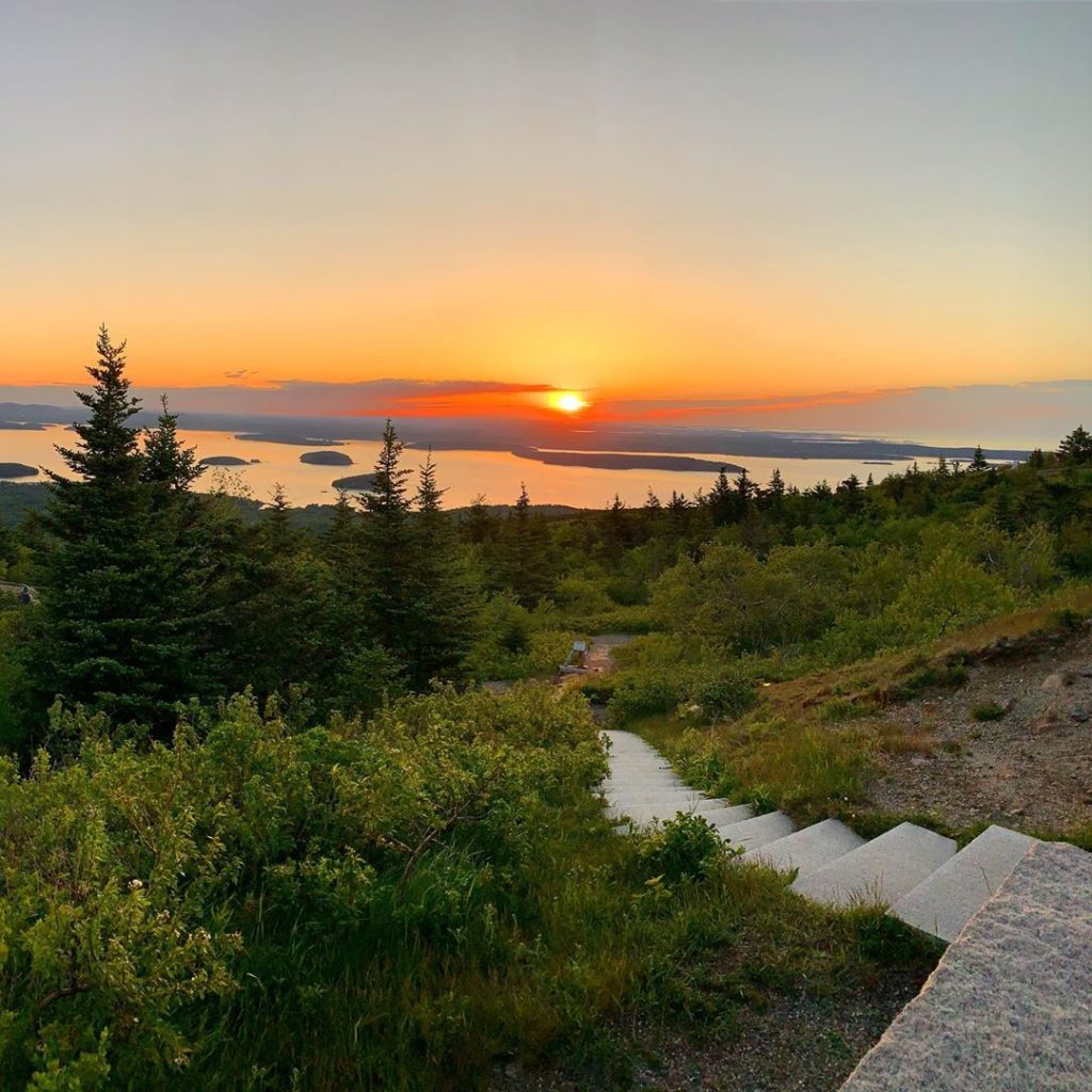
1. Acadia National Park
132,000 Monthly Searches
COVID-19 less popular alternative: Indian Point Trail
As of early July, Acadia is going through a phased reopening. Visit here to see what the up-to-date advisory is.
Phil: I would avoid it in the summertime between Memorial Day weekend and Labor Day, everyone’s on vacation and traveling. It can get super crowded. My favorite time to go is right around May and then September into October. It’s less people. I like May because we still have a lot of snow on the mountain, and if I can get down to Acadia in May I can get my trail legs. The trails are really quiet, and you don’t see many people. The leaves haven’t come out on the trees yet. Then in September/October you have the foliage changing. There’s a lot of really nice hikes there.
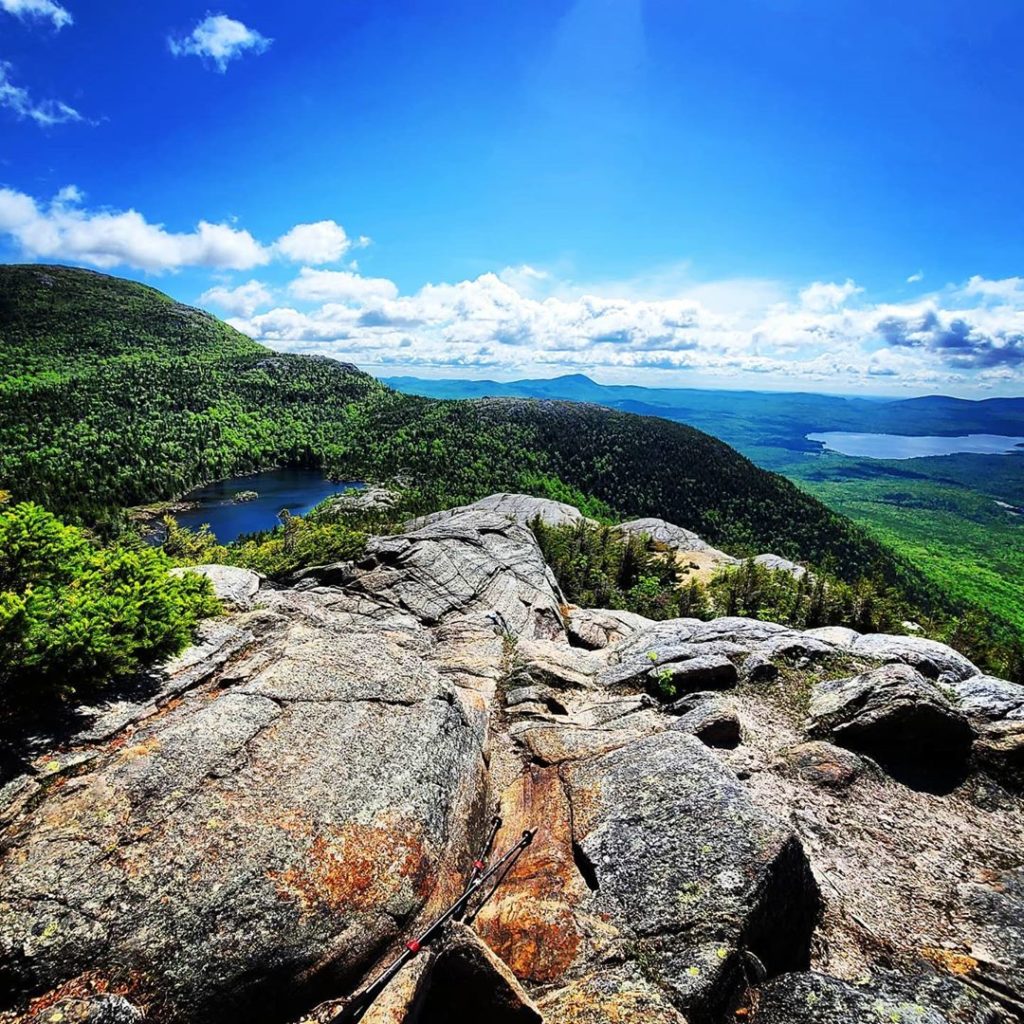
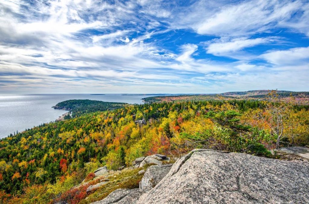
Carey: It’s Maine’s only national park, about 51,000 acres in size. Most of it is on Mount Desert island on the Maine coast. There’s a unit of the park across Frenchman Bay on the Schoodic Peninsula, that’s the only mainland portion. There’s another chunk on Isle au Haut. Between those three major units, there’s about 130 miles of hiking trails. You’ve got the ocean and mountains right together, and that doesn’t occur in too many places in the world. It’s a very special, very dramatic and beautiful landscape. There are 26 named mountain peaks, with six exceeding 1,000 feet in elevation. At 1,532 feet, Cadillac Mountain is the highest point on the Eastern seaboard between Labrador in northern Canada and Brazil. All of this is part of why visitation at Acadia has exploded, it’s gone past three million visitors in the last few years. Fortunately for hikers, only a fraction of visitors ever stray far from the road, so once you get on the hikes you can have a reasonably quiet experience.
Bonnie: Acadia is absolutely beautiful, there are numerous hiking trails over there. Some of my favorites are either up the Southwest Ridge Trail to Cadillac, or hiking up to Penobscot and Sargent Mountains. Dorr and Champlain Mountains are also beautiful. Many of the trails are mostly granite so caution if the trails are wet. They all have great views with a little effort.The downside to Acadia is it’s being loved to death, so the summer can be a little hard as far as parking can be concerned.
2. Cadillac Mountain
11,000 Monthly Searches
Phil: It’s real popular with the tourists because you can drive to the top. There are also four main trails, and any one of them is outstanding. I do a lot of loops there. If you’re starting at Black Woods campground can go on the South Ridge trail, it’s about three miles. It’s real gentle. You get a lot of nice views along the way. I usually try to do 10-15 miles there. A lot of really nice day hikes there. I’d avoid it in the summertime, because by the time you get to the top there will be a couple hundred people who drove up there.
Carey: Cadillac Mountain is the highest mountain in Acadia National Park, 1,532 feet high. That’s elevation right from sea level. It’s a good healthy climb. There’s an auto road to the top, so the summit can be crowded on nice summer and fall days The views are unobstructed. You can see the Frenchman Bay, the islands offshore, a good chunk of inland Maine. I like to hike the Cadillac North Ridge Trail and Cadillac South Ridge Trail. It’s a six-mile ridgetop traverse and one of the longest continuous hikes on the island. You do have to pass by the summit gift shop and parking lot and restrooms and all that en route, but it’s still one of my favorites.
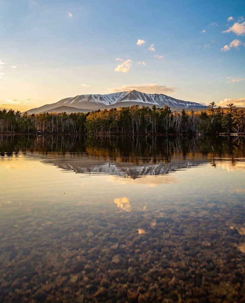
3. Baxter State Park
11,000 Monthly Searches
COVID-19 less popular alternative: Little Boardman Mountain
Check the latest advisory for Baxter State Park here before you go.
Phil: I’ve done almost all of the trails in the park. One of the outstanding features is Katahdin, it’s a really rugged hike no matter which trail you use. The northern part of the park has fewer people but can give you a more of a wilderness feeling so to speak. You can hike mile after mile. It’s more popular with fishermen, if you’re looking to hike and fish it’s outstanding.
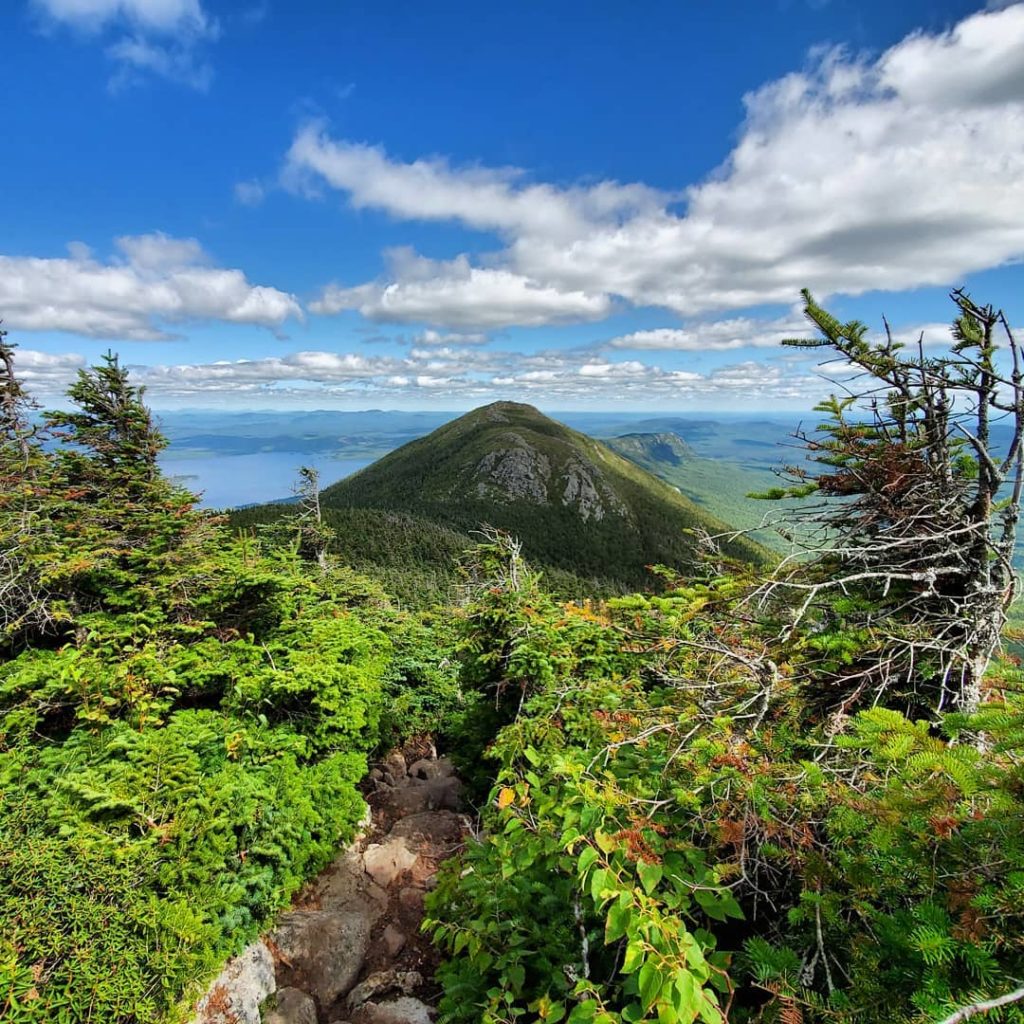
Carey: It’s located in north-central Maine. It’s Maine’s largest state park at 210,000 acres. It’s considered Maine’s largest wilderness area, although it’s officially federally-designated wilderness. It’s considered wilderness because it’s kept in a wild state, by design of the man who established the park back in the 30’s, Percival Baxter, former Maine governor. From the 1920s to the mid-1960s, Baxter purchased land and donated it to expand the park, which eventually added up to 210,000 acres. It’s a beautiful wilderness park, with probably over 200 miles of trails. The iconic feature is Katahdin. It’s 5,268 feet high. We call it mile-high Katahdin.
Lester: With over 225 miles of trail, BSP offers an exceptional opportunity to hike over many mountains and visit all types of ecosystems, including lakes, streams, wetlands and the northern forest. Governor Percival Baxter, the donor of the park, envisioned that the park would provide a “sanctuary for wild beasts and birds” and where people would walk to experience nature. BSP has become the premier destination for hiking in Maine.
Climbing Katahdin, Maine’s highest peak continues to become more popular. During the summer and fall large numbers of hikers coming to the park result in long lines at the park gates. The park deliberately provides limited parking at trail heads to prevent overuse. It is recommended to research and plan for your visit to the park in order to assure having a good experience.
Bonnie: The crown jewel is Mount Katahdin. Difficult hike. There’s no easy trail up Mount Katahdin. The Travelers in the northern park of the park are a beautiful, challenging hike. Most folks want to head to Katahdin but there are other great mountains which won’t be busy or have parking issues.
4. Mount Katahdin
7,500 Monthly Searches
Phil: It’s in the southern part of Baxter State Park. If you just show up, there might not be room for you, so I recommend making reservations. The Katahdin woods and National Monument is right next door, so it’s getting popular now. It’s put a lot of additional pressure on the park. Highest mountain in Maine, a number of different hikes you can do. It’s an all-day hike, no matter which trail you take up there. If it takes four or five hours to go up, it’s four or five to go down. One of my favorite hikes is to go up the Abol trail, which joins with the Hunt/Appalachian Trail, and you can take that to Baxter Peak, turn around, trace your steps and take the Hunt trail down to the Katahdin Trail. A lot of people want to do the Knife Edge trail, there’s nothing like that one, but you have to take the other trails to get up to it.
Carey: All of the hiking trails on Katahdin are spectacular and strenuous. Give yourself eight to ten hours on a summer day. It’s one of the most spectacular hikes you can take anywhere in the northeastern US. The top of the mountain is connected to Pamola Peak by what’s known as the Knife Edge. Sections of Knife Edge are only a couple of feet wide with a drop off of a thousand or more feet on either side. It’s all above timberline with unobstructed views. Katahdin Maine’s highest mountain and a true icon for the state. Baxter Peak on Katahdin is the northern terminus of the Appalachian Trail, which extends from there 2,190 miles to Springer Mountain in northern Georgia, its southern terminus.
Lester: Baxter State Park includes Katahdin (Abenaki for “Greatest Mountain). At 5267 ft. it is the highest mountain in Maine. It is often described as a granite monolith that rises above forests that surround it. The character of the mountain is comparable to having a piece of the Colorado Rockies dropped into Maine. A hike of Katahdin can involve up to 3,800 ft. of vertical rise over a distance of 3-1/2 to 5 miles. Several Glacial basins with headwalls up to 2,600 ft high lead to the “Table Land”, a high plateau, home to Arctic-Alpine Tundra similar to that found on the southern coast of Greenland. One of the most famous trails is called the “Knife Edge” which traverses a narrow mile long ridge with over 2,000 ft drops on either side. Katahdin offers exceptional high elevation terrain for both hikers and mountaineers.
Bonnie: I was just there Labor Day weekend. It’s so remote that when you get to the top, you don’t see anything but the landscape. There’s no roads, no buildings. On top of Katahdin, you look down at Chimney Pond, that’s a fantastic view. The Knife Edge is gorgeous, very challenging. Not for people who have issues with height at all. Another one up there is Hamlin, which is across the tableland from Katahdin. That’s a gorgeous challenging hike and has its own mini Knife Edge. Compared to Katahdin, the views are just as spectacular. No one seems too interested in the other peaks. If you go to the northern part of the park, and you camp out at South Branch, there’s the Traveler Loop, it’s about ten miles and it’s not ever crowded at all. There’s a lot of great hiking up there. It’s totally underutilized. If you do want to do Katahdin, it behooves you to reserve a parking space as on the weekends you most likely won’t get a space.
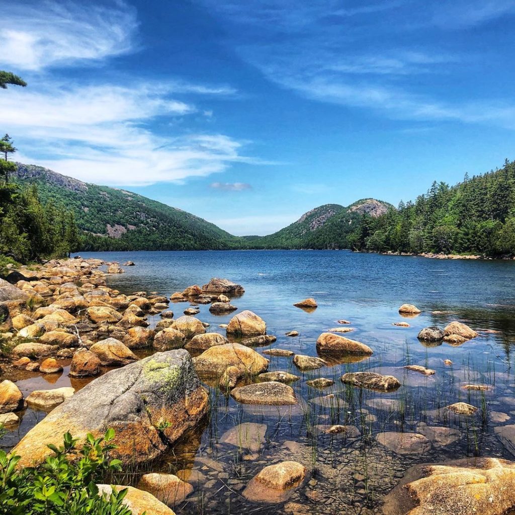
5. Jordan Pond
2,500 Monthly Searches
COVID-19 less popular alternative: Beech Mountain
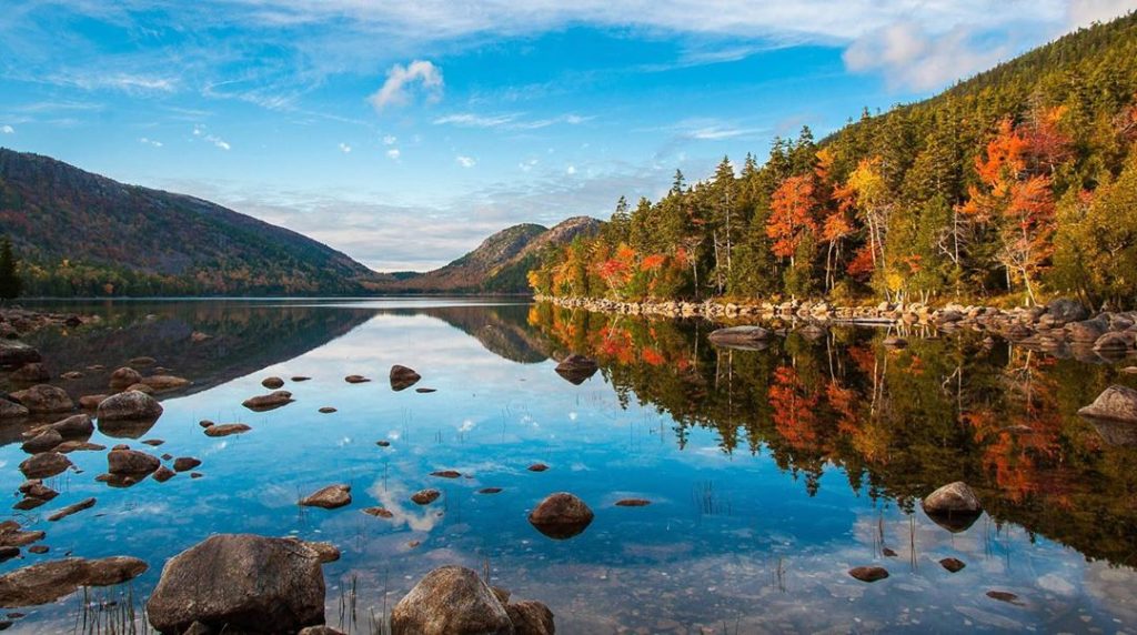
Phil: You can drive right to that, it’s right in Acadia National Park. It’s called a teahouse, they have souvenirs and stuff. If you look across, you can see the Bubbles, which is a nice hike. You can do a nice loop hike around the pond. There are also a lot of outstanding carriage paths you can connect to at Jordan Pond, you can ride bikes there or ride horses. They’re excellent for walking too.
Carey: Jordan Pond is located in the heart of Acadia National Park on the eastern side of Mount Desert Island. Very popular, the Jordan Pond House, located near the south shore, is famous for its popovers and tea and lemonade on the grassy lawn. There’s a great view up the pond from there toward the Bubbles, two very shapely peaks. It’s a beautiful, very famous view, painted by artists like Frederick Church. Jordan Pond is one of Maine’s clearest, cleanest lakes; there’s a 4-mile trail that goes all the way around it, an absolutely wonderful, beautiful hike.
Lester: Jordan Pond is one of the most popular places in Acadia National Park. It is a hub for the trail network on the East side of the park. This combined with the Jordan Pond House Restaurant, which has provided snacks and meals for over 100 years lets hikers can finish their day enjoying tea, popovers and other treats in a beautiful setting. The mountains that surround Jordan feature open ledges with views across the island and the Ocean. When Samuel de Champlain explored this area, he referred to the island as Mount Desert because of it’s expansive and bare mountains.
Bonnie: There are several options for Jordan Pond. Hiking trails, biking on the carriage paths, etc. There’s a beautiful walk around Jordan Pond. On the backside there are lot of boardwalks, which makes it a real easy family friendly hike. There are great views of the Bubbles Mountains. You see these mountains from the Jordan Pond House. The big downside is parking. I believe in 2021, for Jordan Pond, Sand Beach, Thunder Hole, you’ll have to reserve parking. They do provide a shuttle service to all the major points.
6. Precipice Trail
2,100 Monthly Searches
COVID-19 less popular alternative: Canon Brook
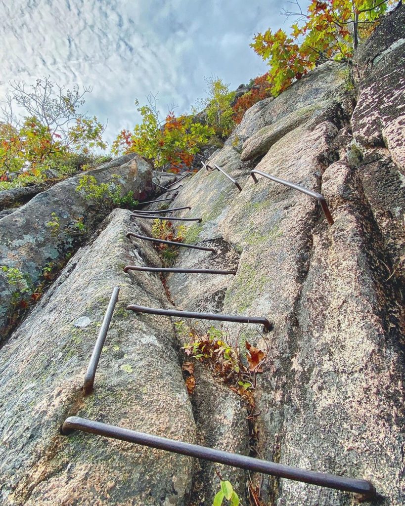
Phil: That one’s scary. It can be closed sometimes because there are nesting peregrine falcons there. Most of the trail is a lot of iron bars placed in the rock that you have to hold onto. It’s like a ladder trail. If you have a fear of heights you don’t want to do this one… it’s white-knuckle the whole way.
Carey: One of the most famous trails in the park. Acadia National Park has a number of what are called “ladder trails.” Technical in nature, in that they have a combination of ladders, hand railings, iron steps, and such to aid the hikers getting up the trail. The Precipice is the most famous of all. A lot of exposure, some may consider it dangerous. You don’t want to do it in wet weather. It’s a spectacular experience, goes right up the east face of Champlain Mountain. You’re really exposed in a lot of these places. It’s not all a white-knuckle experience, though. If you love that kind of challenge and exposure and airiness, it’s like no other trail, it’s just fantastic. Once you get up there you have a view of Frenchman Bay.
Bonnie: Not for the faint of heart! I personally have only done it once, and I vowed I won’t do it again. There was one spot where the granite was sloped and it was wet, and if you slipped you’d take a really nasty tumble. It’s possible the Parks Service has put in rungs there since then, but I was really nervous about that spot. It’s considered challenging, you’re using rungs, ladders, and although it’s not considered technical climbing, it’s not too far from it either. For a good chunk of the summer it’s closed for the peregrine falcons, and you can’t hike it until after the babies have fledged.
7. 100 Mile Wilderness
1,700 Monthly Searches
Note: Before you go there, check the Appalachian Trail Conservancy latest advisory on the Maine section of the Appalachian Trail.
Phil: It basically extends from Monson all the way to Abol bridge. It’s 100 miles, and it’s the last 100 miles of the Appalachian Trail. It goes by a dozen lakes, hundreds of streams and rivers, there’s lean-tos, it’s pretty rugged. I have two re-supply options in the middle so you don’t have to carry so much. It takes most people 8-10 days to hike the whole thing. That’s an outstanding hike, one of the best on the entire Appalachian Trail. Acadia is all day hiking. Whereas the 100 mile wilderness… people might do 50 miles one year, another year they do another 50. I know at least 20 ways in and out, it can be a day hike, but it’s not easy. It’s more remote, takes a lot of planning. I have guests that come and they have a week’s vacation. I’ll plan a 2-3 day overnight hike for them in the wilderness, then I send them down to Acadia, so they get the best of the mountains, but also some of the oceanside hiking that Acadia has, it’s kind of the best of Maine. There’s two major logging roads that bisect the 100 mile wilderness; if you use the Katahdin Ironworks road that’s 30 miles, if you do the other road, it’s about 50 miles. Those two roads are the major arteries, and they have branches that can connect to other parts of the Appalachian trail.
Carey: It’s located southwest of Baxter State Park and is about 750,000 acres in size. It is not true wilderness at all, but it’s very, very wild and a combination of private and public lands. It’s traversed by the Appalachian Trail. The Wilderness got its name back in the 80s from the guidebook author Steven Clark; he coined the name 100-Mile Wilderness to alert hikers to the fact that there were no resupply points in that 100-mile stretch of the Appalachian Trail. It’s the longest stretch of the entire AT without a resupply, and nowhere does the trails to cross a paved road. It’s a wonderfully mountainous region, very remote, very wild, lots of lakes and clear streams and rivers. A lot of conservation work has been done there over the last 20 years, preserving much of the region.
8. Beehive Trail
1,500 Monthly Searches
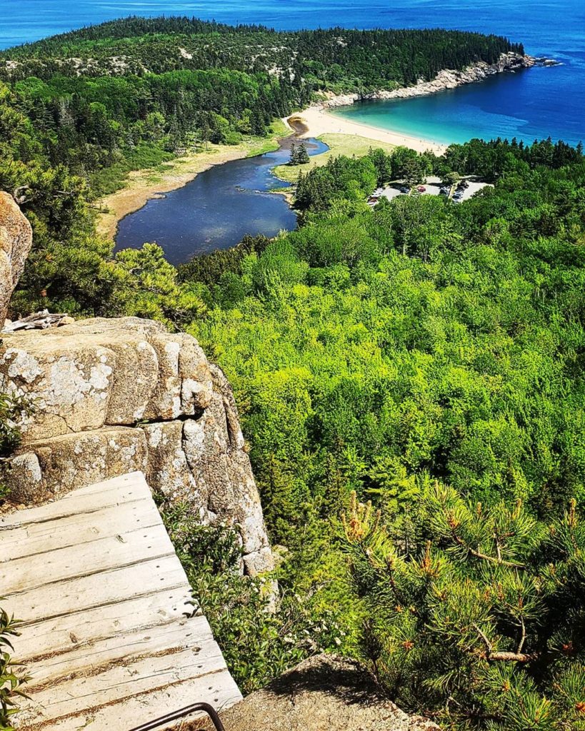
Phil: Beehive is in Acadia too. I always recommend it to my guests. That’s another ladder trail, if you have a fear of heights, you don’t want to be doing it. It’s outstanding, one of my favorite all-time hikes. It only takes 20 minutes. Most people will park down at Sand Beach. I usually go up Beehive, go down the backside, and then I go over Gorham Mountain, and then Ocean Drive along the coast that goes back to Sand Beach.
Carey: Just south of the precipice. It’s kind of a mini version of the precipice trail. The Beehive is another granite cliff-faced mountain. It’s got a very steep southeastern side. It’s another one of the park’s ladder trails. It’s a shorter version of the precipice. Right above the sand beach, the only natural sand beach on the island. It’s very popular with families and kids. It’s not a mile to the top. You get a big view, very spectacular. All of these challenges with railings, walkways and ladders. It’s a lot of fun. When you get up to the top, you can do a loop down the backside, and there’s a little pond called the Bowl. Popular for picnicking and swimming in the summer. If you do the loop around it’s about a mile.
9. Tumbledown Mountain
1,500 Monthly Searches
COVID-19 less popular alternative: Saddleback Mountain
Before you go to Tumbledown, check out the Bureau of Parks and Lands: Maine DACF’s advisories on how to safely visit.
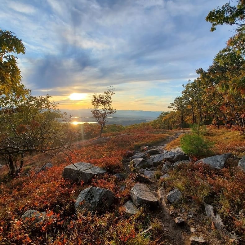
Carey: It’s in the mountains of Western Maine. We have a whole series of high peaks, mountains between three and four-thousand feet in elevation, between the White Mountains of NH to Katahdin. Tumbledown is just over 3,000-feet high. The beauty of the mountain is that features a very dramatic, precipitous south-facing wall about 700 feet high. At the top of that wall is a little tarn called Tumbledown Pond. There are a number of trails up to the top. Tumbledown, Blueberry and Big Jackson and Little Jackson mountains are all part of the Tumbledown Public Lands Unit, about 22,000 acres of public land. And it’s all contiguous to Mount Blue State Park. If I was going to recommend a hike, I’d say drive up to Weld and a few miles beyond, there’s a parking area called the Brook Trail Trailhead. You want to start there, then take the Parker Ridge Trail up to Tumbledown Pond. From there Tumbledown Ridge goes to the west summit of the mountain. You descend via Brook trail back to your car. It’s a spectacular hike and one of my favorites.
Lester: Western Maine features Tumbledown Mountain and nearby Little Jackson Mountain. These together offer several day hikes around the area. Tumbledown Pond, nestled between the two mountains is a popular destination. The Southeast side of Tumbledown has an 800 ft high cliff with challenging rock-climbing routes. The trails range in difficulty from moderate to challenging. The loop trail involves climbing through a 20 ft vertical passage called “Fat Man’s Misery. Tumbledown Mt. is associated with Mt. Blue State Park where hikers can find information and roadside camping.
Bonnie: Probably one of my absolute favorites. There is an alpine pond at the top, which is very rare. People will climb the mountain and go swimming or camp there. Great views, you’re looking out over Webb Lake. There are a couple of different trails up Tumbledown. The Loop trail has a chimney, called “fat man’s misery”. You have to squeeze through this narrow opening between boulders. Packs will have to be thrown up and there are these crazy rungs to help you crawl through. If you’re nervous about that kind of climbing, then take another trail. I’m 5’2, and if there hadn’t been a tall person in my party to give me a boost I wouldn’t have been able to get through the chimney. Probably not recommended for kids at all, and definitely not for dogs. There’s another one called the Brook Trail, very popular. A lot of schools in the area will use that one for field trips.
10. Mount Agamenticus
1,400 Monthly Searches
COVID-19 less popular alternative: Steedman Woods
Note: Visit their site for the latest info.
Phil: It has nice views. We’ve been down there a couple of times to do mountain biking. It’s not really on my radar as a place to go hiking. But for locals in that part of Maine it’s really popular.
Carey: It’s located in southwestern Maine, and the cool thing is that it’s only about 600 feet high but very prominent. As you’re driving north into Maine over the Interstate 95 bridge, you can look off to the north and see this bump of Mount Agamenticus which is really cool. Back in the day, early sailors along the coast of Maine, looking to get to the harbor York, used the profile of Mount Agamenticus to guide them into the harbor. Around the mountain are about 10,000 acres of conservation land, and about 30-40 miles of trails. The summit is open. There’s a nature education center at the top, which is also the site of an old ski area called Big A, which operated in the 60s and 70s. From the top you can see all the way from the Atlantic Ocean to the White Mountains, a distance of about 70 or 80 miles. The trail I’d recommend is the Ring Trail. The Ring Trail leads to a number of shorter trails which get you to the top of the mountain. Mt A lies in the heart of the largest unfragmented chunk of coastal forest on the East Coast between Acadia National Park and the New Jersey Pine Barrens.
Bonnie: Located in southern Maine, that one’s got a lot of different trails, about 10. On a clear day, you can see the Atlantic Ocean and Mount Washington. It’s not difficult. It’s really family friendly hiking there.
11. Gulf Hagas
1,200 Monthly Searches
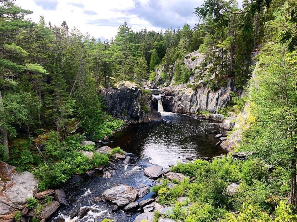
Phil: Called the Grand Canyon of Maine. You’d have to use the Katahdin Ironworks road. If you’re staying at Lily Bay, you’d get to Gulf Hagas by staying there. It’s $10 for locals and $15 for non-residents. You have to pay a gate fee because it’s private land. There’s half a dozen different waterfalls and pools, it’s a good family hike but rugged. You can do it as loop. It is in the 100 mile Wilderness.
Carey: Located in the 100-Mile Wilderness. Considered the “Grand Canyon” of Maine. It is a deep slate canyon through which runs the West Branch of the Pleasant River. There’s a series of at least eight waterfalls. You can do an 8-mile loop hike to all the waterfalls there. It’s certainly one of Maine’s most spectacular hikes.
Lester: The West Branch of the Pleasant River flows through Gulf Hagas which a is a rock canyon with cliffs up to 100 ft high above the riverbed. Referred to as the Grand Canyon of Maine, it has been an outdoor attraction for over 100 years. Hiking to Gulf Hags starts by following the Appalachian Trail where it is necessary to wade across the Pleasant River. At normal summer levels this amounts to walking through thigh deep water with lots of slippery rocks. This is not advisable when the water is high. The Gulf Hagas Rim Trail connects with the A.T. about a mile from the river crossing. The Rim Trail follows the edge of the canyon for 2-1/2 miles with a view of several waterfalls along the way. Upon reaching the upper end of the canyon, the trail loops back along the Pleasant River Road, providing an easier way back to the A.T. The Gulf Hagas Preserve is a part of the Appalachian National Scenic Trail corridor.
Bonnie: Called the Grand Canyon of Maine. It’s remote so a bit of a drive to get there. Absolutely beautiful with deep canyon areas, and areas where there are a series of waterfalls, rapids, and pools.
12. Moxie Falls
1,100 Monthly Searches
COVID-19 less popular alternative: Coburn Mountain Trail
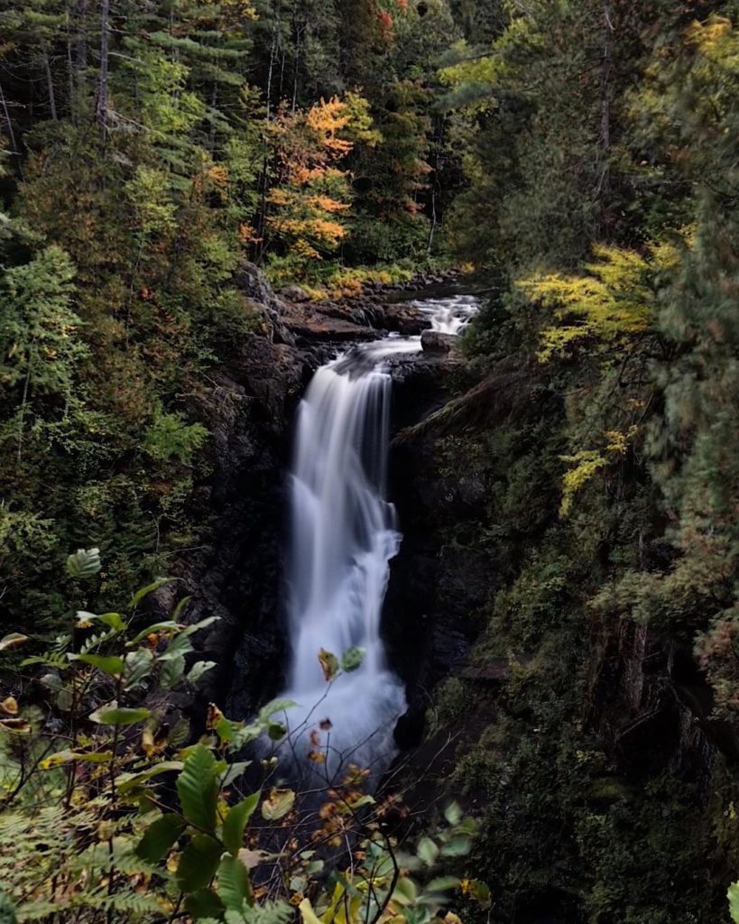
Phil: Nice easy hike in. If you have little kids who you want to introduce to hiking, it wouldn’t be overextending them too much.
Carey: Probably Maine’s most dramatic waterfall. It’s not the highest… but it’s at least 100 feet. The falls is on Moxie Stream, which flows out of Moxie Pond down over Moxie Falls, ending up in a big pool. Moxie Streams continues on to empty into the Kennebec River. It’s a short hiking trail, about .75-mile one-way. There are a number of viewing platforms to see the falls and get some nice photos. If you get there after a rain and the water’s really rushing it’s crazy beautiful. It’s a nice hike to a big waterfall any time of year.
13. Appalachian Trail Maine
700 Monthly Searches
Note: The Appalachian Trail Conservancy has issued an advisory about the Appalachian Trail, check it out here.
Phil: There’s 280 miles of it in Maine. There’s all kinds of day hikes you can do from them and 4,000 foot peaks. The 100 mile wilderness is 100 miles of it. There’s all kinds of different possibilities. If you want to do the whole thing in Maine it takes about a month to do it. There’s over 30 shelters or lean-tos along the way. Outstanding campsites. If you ask any hiker, ask them what their favorite section is they’ll say Maine.
Lester: There’s the Appalachian Trail known as the Hunt trail, which is named after the guy who cleared it.
14. Pleasant Mountain
600 Monthly Searches
Pleasant Mountain is open effective 5/22, but check here for the latest info before you go.
Phil: There’s about half a dozen Pleasant Mountains in Maine. The two most popular are the ones in Bridgeton. It follows an old fire-wardens road over in Western Maine. There’s one in Keraton that’s part of the App Trail; outstanding hike with awesome views. It’s one of those mountains you can get up there and look and not see anything man-made, it’s beautiful. I was just up there three or four weeks ago.
Carey: It’s up in the Bridgton-Denmark area. It’s a four-mile long mountain ridge with a number of different summits. There’s an old Maine Forest Service fire tower on top. There are great views of the White Mountains. I’d recommend going up the MacKay Pasture Trail from the southwest. If you take that trail to the top and explore to the summit it’s about a 4.5-mile round-trip.
Bonnie: There is great hiking, lots of different trails located only about an hour from Portland. My favorite is the southwest ridge trail, it’s got the best views. On nice days you’ve got a great view of Mount Washington. Also known as McKay Pasture Trail.
15. Mount Battie
600 Monthly Searches
COVID-19 less popular alternative: Fernald’s Neck Preserve
Check here for the latest updates before you go.
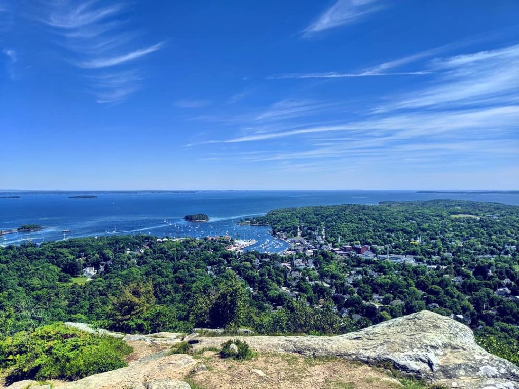
Phil: That’s in Camden Hills State Park. Those are all outstanding day hikes, Mount Megunticook, they’re short hikes that you can drive up to. There’s a little state park campground at the bottom. Awesome views of the little village of Camden and the harbor. In the summertime sometimes they have tall ships, the old sailships. That’s a good family hike. If you have kids and you don’t want to overextend them and show them a good time, the reward is outstanding.
Carey: It’s one of the peaks of Camden Hills State Park, right there on Penobscot Bay in Midcoast Maine. It’s a really nice 3/4-mile trail, one-way, which leaves from just outside the village of Camden. At the top of the mountain, you get great views out over the beautiful village of Camden. There is an auto road to the top, so it gets a little popular, but that’s ok. There’s a stone observation tower at the top, built in 1920 as a WWI memorial; you can climb to the top of it, which looks like a castle turret, and you can see Mount Megunticook and out to Penobscot Bay.
Bonnie: This has an auto road to the top. The summit is open with beautiful views of the Camden Harbor area as well as Acadia. There is also a stone observation tower. Trails can be accessed from the state park or intown Camden.
16. Borestone Mountain
500 Monthly Searches
COVID-19 less popular alternative: Little Wilson Falls Trail
Check here for the latest info before you go.
Phil: I think it’s owned by the Audubon Sanctuary. That’s an outstanding day hike with good parking down below. There’s a caretaker there. It’s a good family hike, there’s a lot of history there. Good views of the lakes. That’s right near where my place is in Monson.
Carey: Situated at the southern edge of the 100-Mile Wilderness. Borestone is comprised of twin peaks about 1,600 feet high, open rock summits that provide wonderful views of Lake Onawa, Moosehead Lake, Big Moose Mountain. There’s the Base Trail and Summit Trail; combine the two and you can climb to the top in about 2 miles. Halfway up, there’s a little visitors center. You’re at the first of three ponds; there’s Sunrise Pond, Midday Pond and Sunset Pond. It’s a wonderful hike, very popular.
Lester: Borestone Mountain is a great hike. It is located whithin a nature preserved owned and managed by the Maine Audubon Society. From the parking area there are both a paved road and a simple trail that brings you to a visitor center on the shore of a pond. After following the shore of the pond, the trail climbs more streeply up stone steps through a boulder field followed by open ledges. Steel rungs and handrails have been installed to provide a safer route. The open summit offers with 360” views of Mountains and lakes in all directions.
Bonnie: Another one with great views, not that difficult of a hike but a drive from southern Maine. It is part of Borestone Mountain Audubon Sanctuary.
17. Gorham Mountain Trail
500 Monthly Searches
COVID-19 less popular alternative: Flying Mountain
Phil: That’s the one I recommended going up the Beehive. When I have people who have only one day to spend in Acadia, I tell them to park at Sand Beach, go over the Beehive, and go to Gorham Mountain. It’s the only hike where you’re along the ocean. The others tend to be in the middle of the island, but Gorham is right along the eastern side of the island. There’s also Cadillac Cliffs, and that’s an outstanding feature, so take the little side trail to go check it out.
Carey: It’s the peak that runs right along Ocean Drive on the eastern edge of Acadia. It’s just south of the Beehive. The beauty of Gorham Mtn are some really cool cliffs called Cadillac Cliffs. There’s a beautiful open ridgeline that stretches all along the coast from Great Head and Sand Beach, all along Ocean Drive down to Otter Cliff. Lots of great views and these cool caves which are actually ancient sea caves.
Bonnie: When you get on the top of Gorham Mountain you’ve got a great view, looking toward Sand Beach and the Otter Cliffs area. That’s a great thing about Acadia, you get a lot of bang for your buck without a lot of effort.
So sad you didn’t add any Northern Maine Hikes. Deboullie Mt, Mt Chase, Hedge Hog, and Haystack are amazing. Also there are plenty of flattish hiking at both of the Outdoor centers (biathlon centers)